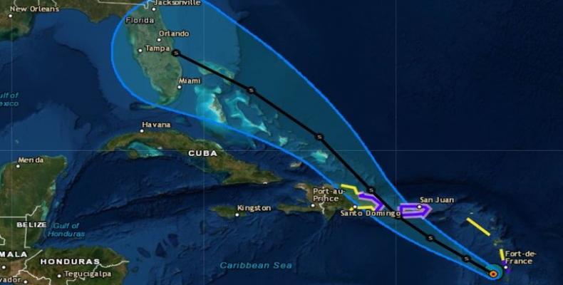
Miami, August 27 (RHC)-- Puerto Rico and parts of the Dominican Republic are now under a hurricane watch because of Tropical Storm Dorian, meaning those places could see dangerous conditions within 48 hours.
Dorian's maximum sustained winds weakened to 50 mph from 60 mph overnight, according to the National Hurricane Center in Miami, Florida. As of 11 a.m. ET, the compact storm was about 60 miles west-northwest of St. Lucia, after crossing into the eastern Caribbean Sea on Tuesday morning.
"Slow strengthening is forecast during the next 48 hours," the NHC says, "and Dorian is forecast to be near hurricane strength when it moves close to Puerto Rico and eastern Hispaniola." Dry air around Dorian has tamped down the storm's strength. And the hurricane center says the system could also weaken substantially when it passes over large land masses in Puerto Rico and Hispaniola.
Questions remain about what Dorian might do after that point, but it seems likely that the storm will persist as it moves to the northwest, toward the U.S. mainland. "The threat of winds and heavy rains later this week into this weekend in the Turks and Caicos, the Bahamas, and Florida is increasing," the National Hurricane Center says. It predicts that the storm's center will move near the Turks on Thursday night.
In its latest forecasts on Tuesday morning, the hurricane center says Dorian's winds will likely weaken but then strengthen somewhat over the next four days. Its sustained winds are expected to top 70 mph shortly after passing over Puerto Rico.
The current forecast calls for Dorian to reach Florida's southeastern coast in the early hours of Sunday morning. Dorian passed by Barbados late Monday night, apparently without causing any severe damage or injury. The island announced an all-clear at 5 a.m. local time.


