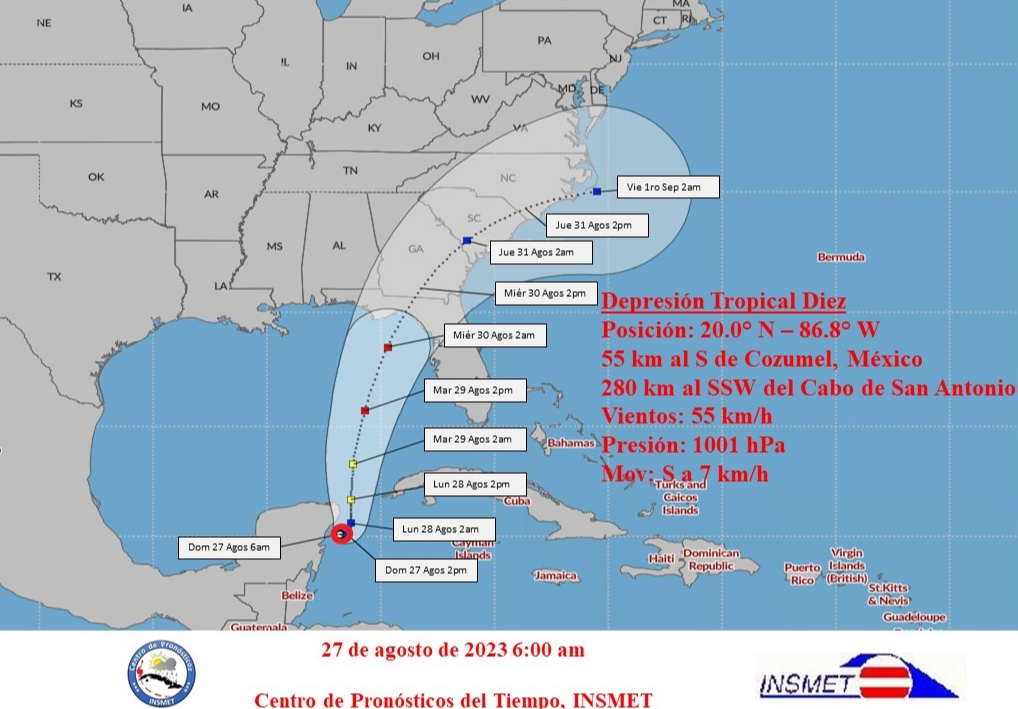
Havana, Aug 27 (RHC) The Forecast Center of the Institute of Meteorology of Cuba (Insmet) in its Tropical Cyclone Warning No. 3, this Sunday reports that during the early morning Tropical Depression Ten has had little change in organization and intensity and remained with slow movement in the seas east of the Yucatan Peninsula.
Its central region was estimated at six o'clock this morning at 20.0 degrees north latitude and 86.8 degrees west longitude, which places it 55 kilometers south of Cozumel, Mexico and 280 kilometers south-southwest of Cape San Antonio in the province of Pinar del Rio.
The tropical depression maintains maximum sustained winds of 55 kilometers per hour with higher gusts. The central pressure dropped slightly to 1001 hectoPascal and has been moving slowly south at only 7 kilometers per hour.
Showers and thunderstorms, associated with this system, extend over the northwestern Caribbean Sea, the Yucatan Channel and western Cuba.
Insmet experts add that rainfall has continued, mainly over Pinar del Rio, Artemisa and the Isle of Youth, which should continue and increase in the rest of the western region during the day.
In the next 12 to 24 hours, this organism will maintain its slow movement, gaining more organization and intensity and could become a tropical storm.
The wide circulation of the system will maintain areas of rainfall over the western region, which could be heavy and intense in some locations.Special attention should be paid to rainfall, due to its persistence and intensity, particularly in the provinces of Pinar del Río, Artemisa and the Special Municipality of Isla de la Juventud. Due to the position and future trajectory of this tropical depression, the Forecast Center of the Institute of Meteorology is keeping a close watch on the evolution of this cyclonic organism.The next Tropical Cyclone Warning on this system will be issued at noon today, Sunday (Source: Insmet).

