By Maryam Qarehgozlou
United Nations, August 20 (RHC)-- The most recent images released by the United Nations Satellite Centre (UNOSAT) show the damage to structures in the Gaza Strip has seen a sharp increase amid the genocidal war. Among the most affected areas are northern Gaza and the city of Rafah in southern Gaza.
UNOSAT’s latest damage assessment, based on satellite imagery released in July and updated building footprints from May 2023 revealed that 156,409 structures have been affected in the Gaza Strip, where more than 40,000 people have been killed in the past 318 days.
The genocidal war was launched by the Zionist regime on the besieged territory following Operation Al-Aqsa Storm on October 7 by the Palestinian resistance led by Hamas. “Of these, 30 percent were destroyed, 12 percent severely damaged, 36 percent moderately damaged, and 20 percent possibly damaged,” the assessment noted.
These correspond to around 63 percent of the total structures in the Gaza Strip and a total of 215,137 estimated damaged housing units, it added. Compared to the May 3 analysis, the assessment explained that the governorates of northern Gaza and the city of Rafah in southern Gaza have experienced the highest rise in damage, with around 2,300 new structures damaged in northern Gaza and around 15,030 in Rafah city.
“Within Rafah, Rafah City municipality had the highest number of newly damaged structures, totaling almost 10,100,” it noted.
Over 80 percent surge in debris
UNOSAT also reported that the ongoing genocidal war has led to a substantial increase in debris generation, totaling 41,946,018 metric tons as of July 6. This represents an 83 percent surge from the initial 22,930,000 tons recorded on January 7, it noted.
According to UNOSAT, various regions experienced varying levels of rise in the amount of debris generated by Israel’s incessant and indiscriminate bombing of the narrow territory during the above-mentioned period, with Rafah seeing an 1149 percent increase, Khan Younis 163 percent, Deir Al-Balah 95 percent, and Gaza Governorate 63 percent.
Notably, the Gaza Governorate recorded the highest overall debris volume during this period. “For each square meter in the Gaza Strip, this recent analysis estimates that 114 kilograms of debris were generated," the report stated.
Using satellite imagery analysis provided by UNOSAT, the UN Human Settlements Programme (UN-Habitat) and the UN Environment Programme (UNEP) have assessed that the volume of debris generated during Israel’s genocidal onslaught in Gaza is 14 times greater than the combined total from all conflicts over the past 16 years.
“The [US President Joe] Biden admin has spent months telling you that is a “limited operation” and Israel has not crossed Biden’s fake red line,” US-based academic and author Assal Rad wrote in a post on X, formerly Twitter, attaching UNOSAT’s image.
UNOSAT May damage assessment
UNOSAT’s assessment of damage and destruction within the area of Gaza in May shows that around 137,297 structures were either damaged or destroyed by the Israeli bombings.
These correspond to around 55 percent of the total structures in the Gaza Strip and a total of 135,142 estimated damaged housing units.
The May assessment also indicated that the governorates of Deir Al-Balah and Gaza City have experienced the highest rise in damage compared to the April analysis.
Within Deir Al-Balah, it said, Nuseirat municipality had the highest number of newly damaged structures, totaling 1,216.
UNOSAT April damage assessment
In April, UNOSAT estimates suggested that around 123,706 structures have been impacted that represent about 50 percent of all structures in the area, and a total of 128,904 estimated damaged housing units.
Khan Yunis Governorate, it said, has been particularly affected at the time, experiencing the highest increase in damage compared to earlier analysis in February.
Within Khan Yunis, the municipalities of Khan Yunis City and Al Qarara have been hit the hardest, with 1,430 and 1,353 newly damaged structures, respectively.
UNOSAT February damage assessment
According to UNOSAT’s images collected in late February 2024, nearly five months into Israel’s genocidal war against the Palestinians in Gaza, a total of 88,868 structures were damaged or completely destructed in Gaza.
These correspond to around 35 percent of the total structures in the Gaza Strip and a total of 121,400 estimated damaged housing units.
The governorates of Khan Yunis and Gaza have experienced the highest rise in damage, with 12,279 new structures damaged in Khan Yunis and 2,010 in Gaza.
Earlier assessments
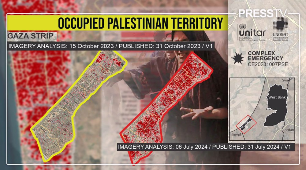
Based on the images collected on October 15, 2023, only a week after the Israeli regime unleashed its all-out war against the besieged territory, a total of 10,584 structures, corresponding to around four percent of the total structures in the Gaza Strip were destroyed or damaged to various degrees.
On November 7, 2023, the number of damaged or destroyed structures increased to a total of 27,076, representing around 12 percent of the total structures in the Gaza Strip.
The areas most affected by damage were the governorates of northern Gaza and Gaza City.
Within less than 20 days, on November 26, 2023, images collected by UNOSAT revealed that the damage had increased to around 18 percent of the total structures or 37,379 structures.
Again, the governorates of northern Gaza and Gaza City have experienced the highest rise in damage, with 3,806 new structures damaged in northern Gaza and 6,243 in Gaza City.
In January, data revealed that around 30 percent of the total structures, or a total of 69,146 structures were completely or partially destroyed since the war began.
Damage to Gaza’s road network
Based on an image collected on May 29, UNOSAT identified approximately 1,100km of destroyed roads, 350km of severely affected roads, and 1,470km of moderately affected roads.
“From these statistics, it has been calculated that approximately 65 percent of the total road network has been damaged (including destroyed and affected roads), across the Gaza Strip,” the assessment added.
Damage to Gaza’s cropland
In July, UNOSAT, in collaboration with the Food and Agriculture Organization of the UN (FAO), released an update on the health and density of cropland in the Gaza Strip.
“Compared to the average of the previous seven years, approximately 65 percent of the permanent crop fields in the Gaza Strip exhibited a significant decline in health and density in July 2024,” the analysis said.
The report includes damage assessment for orchards and other trees, field crops, and vegetables which roughly cover 41 percent of Gaza’s total area, according to recent estimates by FAO.
The assessment also shows that there has been a notable escalation in the destruction of cropland within the Rafah Governorate, with the percentage rising from 52 percent in June 2024 to 55 percent in July 2024.
The deterioration of croplands, which play a pivotal role in marinating food security, is attributed to war-related activities, including razing, heavy vehicle movement, bombing, and shelling, it added.